Latest UAS Lidar Technology Delivers Quality Data More Efficiently
 By Paul Crocker
Lidar isn’t just for airplanes anymore. With the advent of large, extremely stable unmanned aerial systems matched with quality lidar sensors, it’s possible to gather dense and feature-rich data over a 50-acre area in a single flight.

About the Expert:
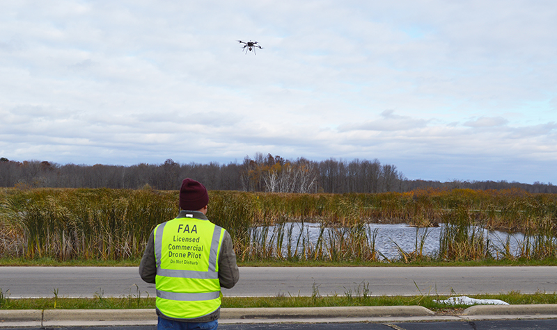
Paul Crocker, an FAA certified UAS pilot with 20-plus years of GIS experience, manages Ayres’ UAS program, which includes 11 FAA certified UAS pilots, including several who operate the pride of our fleet, a BFD SE-8 airframe with a RIEGL miniVUX-2 UAV sensor. Paul maps out strategies to meet clients’ data needs and connects clients with experts from Ayres’ many disciplines to meet any additional needs.
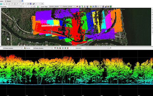
How Can UAS Lidar Point Cloud Data Be Used?
 On projects covering hundreds of acres or corridors up to 20 miles long, UAS-based lidar (light detection and ranging) is an efficient way to quickly deploy and deliver:
- Terrain models used in the planning and design of transportation, municipal, and utility infrastructure projects.
- Documentation of existing assets for utilities.
- Vegetation management around utility infrastructure.
What Advantages Does UAS Lidar Deliver?
UAS-based lidar is particularly effective on medium-size deployments and provides fast turnaround of highly accurate data with the option of colorized point clouds. Ultimately the power of UAS lidar is its flexibility in the trickiest of situations, such as topographic mapping for flood mitigation on the west shore of Green Bay, which has large areas of wetland bog. The legwork involved in covering this area with traditional survey equipment would last over a week, while the necessary UAS lidar flights and ground control could be accomplished in a little over a day.
Here are some of the strategic advantages:
- Boasting accuracies comparable to manned aircraft but with quicker deployments, UAS lidar slots in between projects bigger than a small traditional survey deployment and smaller than a large manned aircraft mobilization.
- Less constrained by weather as compared to manned aircraft. Given the low altitude of acquisition, on a cloudy day UAS lidar can operate under cloud cover, resulting in greater flexibility for scheduling flights.
- UAS lidar can penetrate heavily forested areas to reach the ground and create an accurate terrain model quickly. Traditional survey may require cutting lines across such an environment to map it.
- It’s a cost-effective, quick solution that can collect lidar for an area over 50 acres or along a 1.5-mile corridor in a single flight. Upon the completion of the flight, the system can be serviced and be back in the air in 10 minutes to conduct another flight.
- It allows for targeted management of vegetation along utility corridors rather than on-the-ground inspection of an entire corridor, saving time and money.
- Oblique RGB cameras allow us to colorize the point cloud so that assets are not only accurately located, but easily recognizable too.
About UAS Lidar Equipment:
Ayres is one of a handful of firms in the Upper Midwest that owns and operates a UAS system with a RIEGL miniVUX-2 UAV lidar sensor, considered to be the gold standard for unmanned airborne laser scanners. RIEGL sets the standard for quality, precision, and consistency, delivering remarkable data across a variety of project types. Ayres’ system is built around the following:
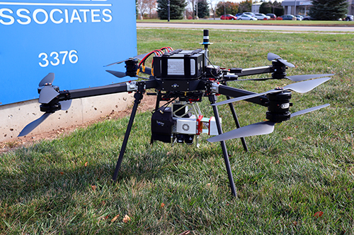
- BFD SE-8 airfame (manufactured in the U.S.)
- GeoCue TrueView 620 lidar system
- RIEGL miniVUX-2UAV sensor
- Applanix APX-20 IMU
- 200 KHz PRR / up to 5 returns per pulse
- 2-5 cm or better precision & RMSE network accuracy
- Dual oblique RGB cameras
- 25 to 35 minutes of flight time
- Potential for BVLOS operations
Contact Paul Crocker for more information on Ayres latest UAS lidar offerings or any of our other geospatial services.


Post a comment: