What’s New in Geospatial? Five Takeaways from Geo Week 2022
 By Karen Shank
In the geospatial realm, technology evolves at Mach speed, and it’s critical we keep our pulse on emerging trends and techniques. Professional conferences are a great way to network with peers, learn from industry leaders, and stay abreast of what’s ahead. In our industry, there is no greater stage for this than Geo Week, a leading event for professionals in our field. Learning, hearing, and sharing different perspectives and experiences is what keeps us coming back year after year.
Geo Week 2022 was a chance for us, along with seven of our Ayres colleagues, to hear (and present) not just about technology but also learn more about up-and-coming applications and broaden our knowledge base about best practices – all in the name of delivering the highest-quality end products possible to our clients and industry partners.
Here are our top 5 takeaways from our time at Geo Week.
5. Asset Management
New sensors are bringing unprecedented levels of data fidelity and quality to asset management applications. Conversely, new software is providing powerful workflows to process this data, helping us derive critical information for asset owners and operators. Structure inspections, pavement surface evaluation, expansion of broadband services, and maintenance of transmission and distribution networks to ensure reliable delivery of power are all examples of where asset management benefits from combined sensor and software improvements showcased at Geo Week. With the recent approval of the infrastructure bill, Ayres is excited to help clients navigate the process of securing funding for their projects and applying new technology in innovative ways.
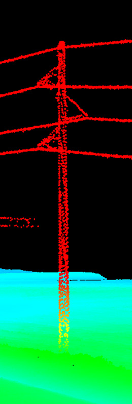
4. 3D Data Collection
Definition and fidelity for feature(s) of interest are critical to the application for which 3D data is being collected. High-density airborne lidar systems help tremendously with this for the projects that Ayres and other firms like us tackle daily. We were happy to see sensor manufacturers continuing to innovate and push the envelope so that we may follow suit in the identification of new applications for 3D data collection for our clients.
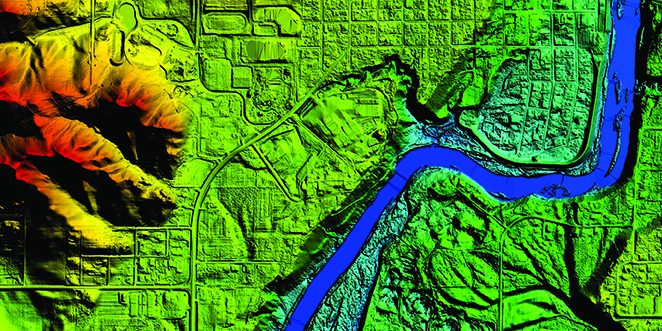
3. USGS/3DEP Update
The U.S. Geological Survey (USGS) manages a national lidar program known as 3DEP (3D Elevation Program), which was developed in response to increasing needs for high-quality topographic data and three-dimensional representations of the country’s natural and built features. The program’s goal is to provide the first-ever national baseline of consistent, high-resolution topographic elevation data – as both bare earth digital elevation models and 3D point clouds.
With 3DEP, Quality Level 2 data or better is available or in progress for about 84% of the nation as of the end of fiscal year 2021. As part of the conference, USGS provided an update on the latest areas of research, program updates for the development of topographic information, including elevation and hydrography data, as well as how the pieces fit together within 3DEP. Ayres coordinates Wisconsin’s 3DEP and has produced more than 22,000 square miles of lidar statewide. It’s energizing to hear about the progress being made as continually updating elevation mapping is important for a host of projects – everything from construction projects to Federal Emergency Management Agency floodplain mapping to risk assessments to environmental studies.
2. UAS Accuracy Standard Specs
Ayres was invited to a panel session to bring the perspective of a commercial user of UAS lidar and imagery within the surveying and mapping industry. Increased adoption of this technology has bought about positive, ongoing discussions among the Primary Data Acquisition Division (PDAD) and the American Society for Photogrammetry and Remote Sensing (ASPRS) at large in terms of shaping and creating new standards specific to UAS.
Those specifications and standards which exist (USGS Lidar Base Specifications 2.1 and the 2014 ASPRS Positional Accuracy Standards) were originally designed for wide area mapping projects for which UAS is not a suitable approach. Once written, these new standards would ideally help guide and ensure data providers are producing deliverables in a consistent manner and to an accuracy that is realistic and obtainable. One challenge of a new standard revolves around the appropriate number of control and independent check shots given the size and scale of projects where UAS may be used. In addition, the variability in precision of existing and available sensors creates challenges around how these new standards could be conveyed and applied.
1. Pace of Innovation and Technology
It’s remarkable to reflect on the rapid pace of geospatial technological developments. Consider a few recent and emerging innovations:
- Drones/UAVs that can fly for a longer duration. Ayres is in the process of purchasing a new UAV to add to our fleet that will allow for more airtime.
- Collision-avoidance technology.
- Sensors and cameras that are more powerful and accurate than ever. Ayres has and is in the process of purchasing additional lidar sensors and photogrammetry-approved cameras.
- Artificial intelligence (AI), machine learning (the study of computer algorithms that can improve automatically through experience and by the use of data), and reality capture that is expanding the level of uses, accuracies, and volume of data. Machine learning models can make predictions and decisions without being explicitly programmed to do so. Ayres is actively working in these areas, along with working with partners that specialize in these technologies.
- Software that is faster and has more compatibility to existing workflows and for building out new ones. Ayres is consistently updating and purchasing new software and workflows to bring better deliverables to our clients.
- Large industry leaders such as Facebook, Google, Uber, Microsoft, and more now taking part in research and development of lidar, drones, AI, and machine learning that can help with pushing these technologies further and build confidence and buy-in not just from the political and legislative side, but from the communities and industries they serve.
While innovation and technology has been continually evolving, Geo Week still recognizes and appreciates the old and methodical ways things were done in the past and, in some cases, still practiced today. But, due to the fast pace and sheer volume of construction and the demands for new infrastructure required to support the ever-growing population, we must evolve and quicken our pace without compromising safety and good work. It is with these same values that we keep pushing innovation and technology to be better than ever. It is also with this pace that we will attract and obtain young, new talent. Twenty-five years from now, our industry will look different, but, hopefully, we can still see a little part of the past too.
With Geo Week Now Behind Us, Where Do We Go From Here?
Geo Week provided an exciting peek into the newest hardware, software, methodologies, solutions, and applications, and so much more. It’s an energizing time to be in geospatial, and we look forward to reaping the rewards of these advancements with our clients and strategic partners and teaching and engaging the next generation of geospatial creators to push us forward and beyond.

About the Expert:
Karen Shank is a business development professional with over 25 years of experience in diverse industries, including drone software development and analytics, nano/biotech, pharmaceuticals, and information technology. Working in Ayres’ Geospatial Division, she focuses on helping clients achieve their business objectives and helping our geospatial professionals build strategic partnerships.
Looking to learn more about what’s new in the geospatial industry? Or maybe you’ve just got some questions? Reach out to any of our geospatial professionals.


Post a comment: