How to design telecom networks accurately, safely, efficiently: The geospatial approach
By Nik Anderson and Zachary Nienow
Integrating geospatial technology into telecom design leverages data from remote sensing to map out existing conditions in the field. Collectively this includes imagery, lidar, and GIS data for the accurate location and measurement of existing infrastructure. Geospatial data for telecom design comes in three main categories:
Underground utilities, which are identified at the ground surface in mobile lidar and imagery and mapped out by utility and asset type:
- Utilities include water, sewer, gas, electric, traffic, and telecom
- Asset types include cabinets, handholes, pedestals, manholes, valves, hydrants, and traffic signals
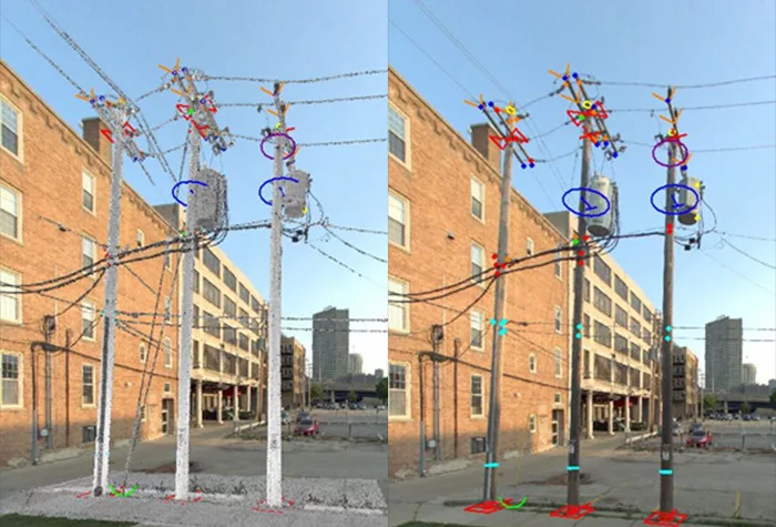
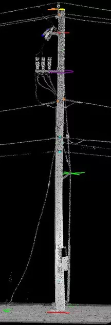
Poles and pole attachments, which are identified in mobile lidar and extracted to include:
- Pole locations, pole attachments, mid-spans, and guy wires
- Measurements are calculated, including height to lowest attachment, clearance to lowest power, guy attachment height, and pole height
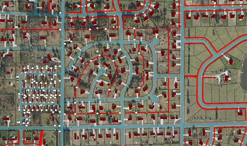
Base mapping, which uses existing data to map out:
- Edge of pavement, road centerlines
- Building outlines
- Wetlands, soil types
- Culverts, bridges, railroad crossings
- Public right-of-way, public utility easements
The extracted linework and point data are packaged in GIS or CAD format for seamless integration into the design process.
Struggling to maintain enough field staff for data collection?
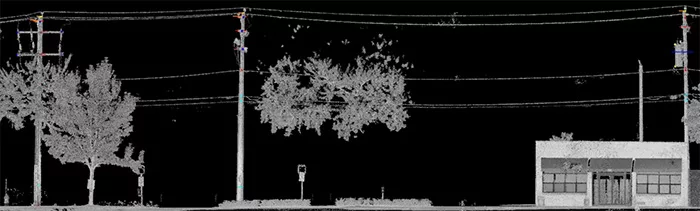
What is Lidar?
Lidar, which stands for light detection and ranging, is a remote sensing technology commonly used to derive measurements of the earth in a three-dimensional environment. The lidar sensor emits millions of pulses of light that come into contact with various features or surfaces before returning back to the sensor with a value that allows for creation of a 3D point cloud. Ayres is a national leader in lidar processing and data extraction. When it comes to supporting telecom design, we typically use vehicle-based lidar and imagery systems, more commonly referred to as mobile lidar.
Engineering firms use mobile lidar utility extraction to quickly and efficiently conduct fielding of their telecom design network. This approach is most advantageous on larger projects, as it scales the design process and allows firms to focus their efforts on getting more design completed and more permits processed. Collecting and extracting geospatial data should be executed at the beginning of a project to fully cash in on its efficiencies throughout the project.
Hiring experts in geospatial data collection and extraction can really pay off. Ayres focuses on this aspect of the telecom design process and makes sure data is delivered in a way that meets clients’ specifications and standards. Ayres technicians are trained in the latest software for extracting data from mobile lidar and imagery. A team of over 25 full-time employees is dedicated to data creation, helping clients scale their design efforts to meet schedule and budget constraints.
Ayres has developed and deployed a unique technical approach for geospatial-OSP engineering. This approach uses a combination of aerial imagery, mobile lidar, and field review to complete base mapping of existing utility infrastructure, public utility easement research and mapping, constructability review, staking sheet review, and pole make-ready assessments. Ayres has supported thousands of miles of fiber design on numerous projects using this approach.
What are the benefits of the geospatial approach to telecom design?
Is using lidar and imagery better than employing traditional field methods of sticking poles and hand-drawing base map sketches? How do professional geospatial services compare to “drafting” with Google Earth? Here are the advantages:
- Delivers accuracy, speed, consistency, and objectivity
- Keeps staff out of harm’s way (out of the public right-of-way)
- Scales base mapping and existing utility data collection
- Makes design staff more productive by reducing field workload
- Provides a 3D model of the existing environment for design, permitting, and construction
- Extracts additional details from the point cloud as needed throughout the project
- Eliminates repeat visits to the field to capture additional details
- Provides reliable base map and pole data for negotiating with permitting agencies
- Quickly generates make-ready cost estimates from the office
- Uses lidar data to scale up pole attachment applications
- Translates extracted lidar data for pole loading applications
Using the geospatial approach to map out existing conditions expedites telecom projects by supporting the project throughout design, permitting, and construction. And it saves the design team a lot of time that would otherwise need to be spent in the field.
To learn more about how you can have all this accurate data at your fingertips, please reach out to Nik Anderson or Zachary Nienow.

About the Expert:
Nik Anderson, GISP, leads our geospatial-telecom projects from design to delivery, pairing his geospatial expertise with industry knowledge to provide solutions that create foundational datasets, efficient workflows, and reliable data. Nik has led imagery, lidar, and GIS projects across the nation and enjoys staying abreast of disruptive technologies that can best serve his clients.

About the Expert:
Zachary Nienow, GISP, manager of aerial mapping, has extensive experience in digital mapping, GIS, and project management. Zach has designed and led lidar and aerial imagery projects from planning through flight and then data processing, quality control, and completion. Zach has led the development of our geospatial-telecom service line and has been working with telecom clients since 2016.


Comments are closed.