HD Scanning Quickly Gets the Lay of the Land – Or Just About Anything Else You Need Surveyed
When it comes to completing an as-built survey or an asset inventory, HD laser scanning is making amazing things possible – in short order and with exceptional accuracy. HD scanning is the answer if a client needs to check a finished roadway against design criteria, precisely measure a bridge’s clearance, or create a 3-D representation of the existing conditions of a building or park to serve as a backdrop for visualizing the conceptual design of proposed renovations and how they fit into their environment.
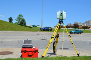
Ayres Associates’ land surveyors are trained to collect data – millions of points per second – via tripod-mounted HD scanners. The surveyors piece together the overlapping scans, and then Ayres’ large geospatial operation extracts the data and produces CADD drawings and various other deliverables that are within 1 mm accuracy when scanned up close and within about an inch if scanned from 400 feet away. Here are some of the many applications for this new technology, which Ayres Associates is offering nationwide:
 Transportation design
- Bridge and overhead obstruction clearance
- Substations and utility infrastructure
- Industrial facility maintenance
- Change detection (load stress and settling)
- Americans with Disabilities Act (ADA) compliance checks regarding sidewalk ramp slopes
- Analysis of discontinuities (such as confirming the flatness of an old factory’s floors to determine what imperfections might need to be corrected for reuse as a hospital or production facility)
Today Ayres surveyors are at the Byllesby Dam in Dakota County, Minnesota, to scan the existing conditions at the powerhouse, where major renovations are being considered. The resulting as-built plan of the powerhouse building will allow designers to virtually remove existing equipment and add proposed equipment while identifying possible conflicts with existing infrastructure in the building, says Jason Ingram, who will become Ayres’ manager of land survey on January 1.
Laser scanning can bring quick and highly accurate imagery and documentation at so many steps along a design process, during construction, and in operations and maintenance:
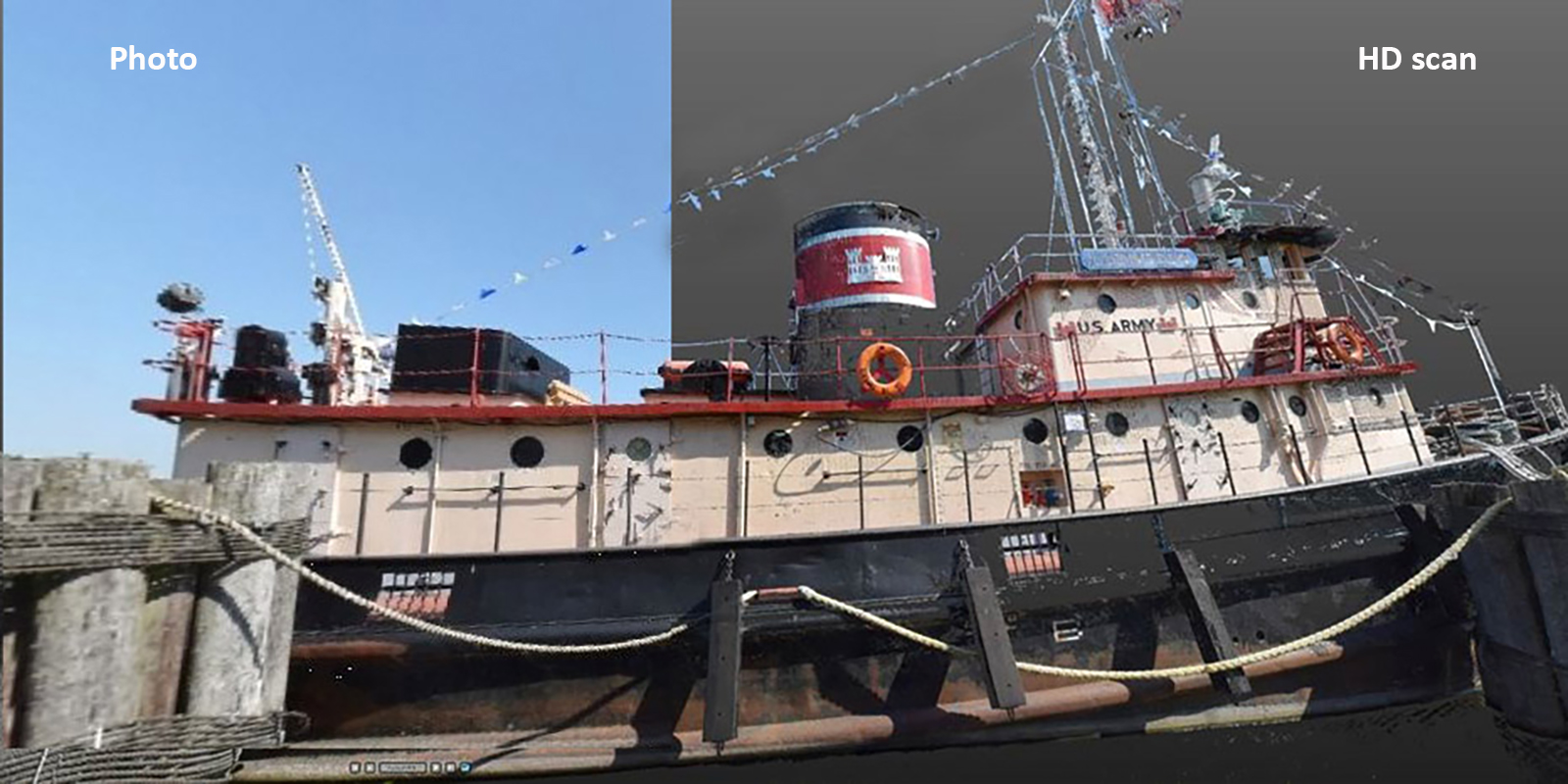
Preliminary park design: In Kewaunee, Wisconsin, HD scanning is playing a role in helping the City and its residents to envision how proposed Harbor Park boardwalks, fishing platforms, parking lot and sea wall improvements, and associated landscaping fit into the existing natural and built environments. One of the resulting animations of the HD scans can be viewed at the top of this post, and an image showing a scan of the park’s World War II tugboat is at the bottom of this post.
Bridge design: In Racine, Wisconsin, detailed HD scans of a 1929 bridge’s terra cotta and tile mosaic features are helping designers to replicate these treasured aesthetic treatments in the new 6th Street bridge Ayres Associates is engineering over the Root River. The scan included details from the surrounding street and a building directly next to the channel wall of the river. All these details were gathered without exposure to heavy traffic or the need to access private property. An animation of the bridge scan can be viewed below.
Other bridge applications: Scans provide an efficient approach to performing vertical clearance measurements and checking as-built conditions’ conformance to design criteria.
Roadway applications: HD laser scanning is being effectively and efficiently used for generating asset inventories, transportation design drawings, and quality control studies of as-built construction. Surveying a busy intersection is safer with an HD scanner than with traditional survey equipment since surveyors never have to enter the intersection to do their work.
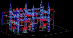 Substations and electric utilities: Electrical utility owners and designers use HD laser scanning to provide asset inventory on existing facilities, to analyze future expansion capacity and existing structural conditions, and to collect as-builts for maintenance. HD laser scan data can be integrated into existing aerial lidar data to create a more accurate and holistic data set. Collection of data using HD laser scanning greatly reduces the need for a facility to be taken out of service for data collection. Ayres Associates provided high-density scanning and 3-D modeling services to American Transmission Company (ATC) at its Highway 8 Substation in Rhinelander, Wisconsin.
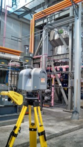 Industrial facilities: Feature extraction and modeling of assets for industrial building information modeling (BIM) is supported by precise, high-definition 3-D laser scanning to capture details of mechanical, electrical, and plumbing (MEP) infrastructure. Mechanical and electrical engineers are using the resulting 3-D models to perform space and load-bearing capacity analysis for expansion. Designers can virtually remove and replace key equipment and determine in advance whether the shape and size of the new equipment causes spatial conflicts with other facilities that necessitate redesign. This can be a big money saver, especially in a production situation where unexpected retrofitting can result in costly down time.
Architecture: The low-impact application of HD laser scanning mitigates safety and damage concerns as architects document the existing site conditions prior to restoration and rehabilitation projects. The highly detailed information captured by these systems greatly increases the quality and accuracy of designs replicating desirable features of the existing building. Architectural designers and MEP engineering staff have the ability to design in 3-D.
HD scanning replaces or minimizes the need for topographic survey in many situations. For example, the data from a scan of a roadway can be vectorized, and then line work can be laid out in a CADD drawing. HD scanning also provides such comprehensive data that returning to the site to capture more data is rarely necessary.
If you’d like to discuss the potential benefits of HD scanning, contact our Geospatial professionals, who has been named manager of aerial mapping, effective January 1.


Post a comment: