Benefits of 2D Modeling for River Hydraulics
By Dusty Robinson, PE
Two-dimensional (2D) hydraulic models are not new to the industry; they’ve been in use for close to 30 years. However, older 2D models required highly experienced users and the technology was expensive and cumbersome so they were typically only used on complex projects. Recently, advances in computer technology and 2D modeling engines along with increased accessibility of data mean 2D modeling has been growing in popularity in the hydraulic engineering world.

About the Expert:
Dusty Robinson, PE, joined Ayres in 1998 as a civil engineer in the field of water resources engineering. His primary focus is on river engineering studies. He has extensive experience using GPS to support hydrographic surveying and mapping. Other experiences include preparation of plans, specifications, and reports for various projects.
Put simply, a hydraulic model is a digital representation of a river or other waterway that is used to analyze how the system behaves hydraulically. A hydraulic model can be used as a tool to plan future infrastructure improvements, develop maintenance strategies, guide rehabilitation, and be proactive in anticipating potential problems with the system.
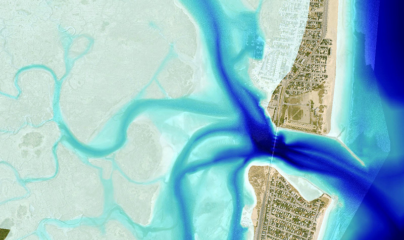
While the goal of any hydraulic model is to accurately simulate actual flow conditions, 2D models have several advantages over more commonly used 1D hydraulic models. Any model relies on assumptions that the modeler must understand; violating assumptions and ignoring limitations results in an inaccurate representation of actual hydraulic conditions. 2D models avoid many of the assumptions required by their 1D counterparts and, as a result, provide a more accurate representation of complex hydraulic conditions encountered in the real world. Additionally, the high visual graphic output of 2D models makes it easier for engineers to convey their results and concepts to non-technical stakeholders.
Benefits of 2D Models:
- Fewer modeling assumptions and less user judgment can yield results that are representative of actual conditions.
- Enhanced communication with stakeholders with engaging graphics, videos of flow paths, and georeferenced results.
- Accurate representation for complex conditions, including wide floodplains, sinuous channels, multiple channels, bends and confluences, bridge/roadway crossings, roadway overtopping, skewed roadway, tidal waterways, and bridge scour, among other conditions.
The Federal Highway Administration (FHWA) has a strong preference for the use of 2D models over 1D models for complex waterway and/or complex bridge hydraulic analyses. The FHWA published the “Hydraulic Design of Safe Bridges” report which contains information. 1D models are best suited for in-channel flows and when floodplain flows are minor. For extreme flood conditions, 1D models generally provide accurate results for narrow to moderate floodplain widths.
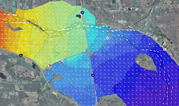
2D models should be used when flow patterns are complex and 1D model assumptions are significantly violated. 2D models generally provide more accurate representations of flow distribution, velocity distribution, water surface elevation, backwater, velocity magnitude, velocity direction, flow depth, and shear stress.
As for time, 2D modeling does not take longer than 1D modeling. Recent advances in software have automated many tasks, making 2D modeling very efficient; in fact, in many cases, 2D models take less effort.
Finally, running a 2D model doesn’t take a special computer or other equipment. Standard office workstations can run most 2D models.
For more information regarding 2D modeling or for other questions, reach out to our River Engineering + Water Resources experts.


Post a comment: