Ayres Lidar Online: Viewing Your World in a 3D Space
By Adam Derringer, GISP
Lidar data has become the accepted authoritative elevation dataset in the world; federal agencies, states, counties, utilities, and the private sector alike budget for this data to help solve problems every day. The problem is, only a few people in any organization can see or use the data because the files are so large and complex.

About the Expert:
Adam Derringer is a senior project manager with more than 19 years of experience in providing geospatial solutions to clients’ needs. He has consulted worldwide on GIS department best practices and workflows and received an international Esri Special Achievement in GIS award. He is also past president of the Wisconsin Land Information Association and chair of the Wisconsin Land Information Council.
To access these critical elevation datasets, they’d either have to go to a state or organizational website and download their own copy of terabytes of data or they’d need to track down the hard drive that data was delivered on, load it, and plug it into a high-end computer that has access to GIS software. (And they need the time and training to know how to bring this slow-loading data in.)
Is There an App for GIS Information?
The Lowdown on Lidar
Lidar, an acronym for “light detection and ranging,” is a means of measuring elevations and distances using laser pulses. It’s similar to radar or sonar but uses an optical source – a laser – instead of microwaves or sound waves. With lidar, a pulse is fired from a sensor and a very accurate distance can be calculated from the object it hits. When you collect billions of measurements in every county, you can build a very complex surface model of the earth.
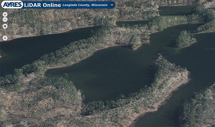
Ayres has worked to train its clients for years to ensure this critical data was being used throughout organizations, but there’s never been a way around issues like the immense file storage requirements or access to software. Ayres Lidar Online provides a solution. The intuitive new tool removes these barriers and puts important lidar data in the hands of everyone.
The 3D, browser-based application allows users to quickly access terabytes of data, including billions of measured points, without purchasing or installing software. Multiple users can access the same data simultaneously, and they can log on from anywhere and on any device.
What Kind of Information Can Be Found with the App?
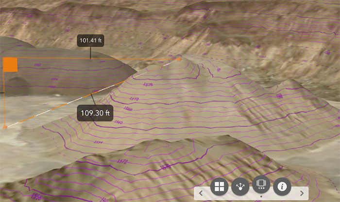
Using the new web app, users can easily measure setbacks for planning and zoning; analyze height restrictions for Federal Aviation Administration compliance; measure the height of tree stands, buildings, and towers; see slopes and percent grades to understand erosion and drainage; find closed depressions to understand water quality; and see elevation change for preliminary construction design in a project area. All of it can be experienced in a realistic, 3D environment vs. a flat 2D map.
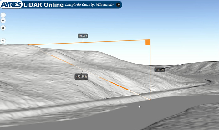 Users decide what they want to see and/or measure. For instance, foresters can review tree stands while highway engineers can measure the elevation change from the bottom of a ditch to the crown of a road. Users can toggle individual layers on and off, zoom to any location in the data, and measure targeted, high-quality lidar data. No GIS training is needed. The app doesn’t take a lot of processing power, so data can be accessed from a phone or tablet from a project site.
Why Does Accurate Elevation Data Matter?
Current, accurate elevation data is essential on many levels for compliance, asset management, or drainage studies. For example, many clients rely on high-quality lidar data to better prepare emergency plans for floods or flood mitigation. Consider the impact if a flat area like Antigo, Wisconsin, receives a sudden downpour of rain. If the surface used to model where that water is going to go is off by 6 inches, a foot, or even 3 feet across the entire city, that is a lot of water going where it wasn’t expected. Inaccurate data can have a major impact on homes and businesses, not to mention public safety. You can view this scenario in our demo Ayres Lidar Online web app.
 Technology is constantly evolving to make our lives better and decisions smarter. Delivering open access to high-quality lidar data with the power of online, cloud-based GIS mapping is one such way.
Contact our Geospatial professionals for more information on Ayres Lidar Online or any of our other geospatial services.


Post a comment: