Task Force Co-Chairs Offer a Call to Action for Wisconsin’s Geospatial Community
 By Dick Kleinmann, and Howard Veregin
Changes are coming to improve the National Spatial Reference System – the system that defines latitude, longitude, height, and orientation – and Wisconsin’s municipalities, counties, and state agencies are going to want to take note of a quickly approaching deadline.

About the Experts:
Dick Kleinmann was a project manager in Ayres’ aerial mapping group and played a leadership role in serving the surveying, mapping, and asset management needs of southeastern Wisconsin counties, municipalities, utilities, and transportation agencies. Dick retired from Ayres in June 2023.

About the Experts:
Howard Veregin was appointed State Cartographer in September 2009. His previous positions include director of Geographic Information Services at Rand McNally, Associate Professor of Geography at the University of Minnesota-Twin Cities, and Assistant Professor of Geography at Kent State University. He received his Ph.D. from the University of California-Santa Barbara in 1991.
National Control Network Is Changing to Incorporate Dynamics of Crustal Movement
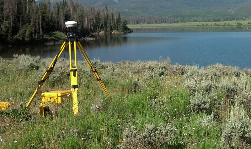
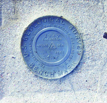
The National Geodetic Survey (NGS) is the federal agency responsible for maintaining the nationwide survey control network. Beginning in the 1800s, the NGS and its predecessor agencies created and maintained this network while gaining a better understanding of the shape of the earth and its dynamic nature. With the exponential increase in surveying accuracy in recent decades, it’s become clear that surveying monuments once thought of as fixed in place are actually moving with the earth’s crust.
 Today any surveyor using GPS equipment can detect this movement over time. Now that roads and buildings are being built with machines following designs loaded into onboard computers guided by GPS, the error caused by crustal movement can no longer be ignored. To alleviate this problem, NGS is developing a nationwide mathematical model of crustal movement using a network of Continuously Operating GPS Reference Stations (CORS). Under the GPS on Benchmarks program, NGS is asking state and local surveyors to collect GPS observations to make the model more accurate.
NGS has identified a list of priority monuments to ensure statewide coverage. You can find those on this NGS web map.
GPS on Benchmarks Program Requests Observations, Provides Benefits to Local, County, State
Participating in the GPS on Benchmarks program has many benefits at the local, county, and state level:
- The model of crustal movement will benefit local, county, and state agencies by facilitating more accurate conversion of old surveying and mapping data to a new spatial reference system to be released by NGS in the next few years.
- The model will be integrated with hardware and software surveyors will use on a daily basis.
- GPS observations are the best way to preserve past investment in monuments and to ensure they are included in the new spatial reference system.
- Monuments with accurate, up-to-date elevations are critical to determining floodplain elevations and verifying surveying and construction projects.
- Monuments with recent GPS observations will have higher NGS accuracy estimates, providing better data for local surveying and mapping programs.
What’s the Deadline for GPS Observation Submittal?
The deadline to submit GPS observations to NGS is December 31, 2021.
Who Can I Contact With Questions?
For more information on this program, contact the Wisconsin Spatial Reference System 2022 Task Force (WSRS2022).


Post a comment: