GIS Day is Cause for Celebration, and Here’s Why

Geographic information systems, or GIS, are the combination of geographical features and powerful databases. Municipal governments and local utilities rely on this technology to gather, manage, and analyze high-level spatial information.
With today being GIS Day, it only seems fitting to discuss some of the ways GIS services meet clients’ everyday mapping needs and streamline the use of transportation, utility, and municipal engineering information.
When developing solutions to fit clients’ needs, we often use GIS as part of the answer – not only by collecting data but also by putting it into a GIS with attributes so clients can begin to more fully use and analyze the information. We don’t just export the data to GIS at the end. Rather, we actively use it to solve problems as part of the workflow.
We’re doing this right now with a project that calls on both our aerial mapping and land survey services – first compiling aerial mapping of a large area to identify where a client’s facilities are located and then merging that data with land record data obtained by our surveyors. From there, construction staking for new facilities can be done based on this facility GIS.
Technicians can conduct their normal survey or aerial mapping routines and at the end convert their AutoCAD files to a GIS format, or they can use the GIS during the process to solve some of the problems encountered. In the case of land records mapping, a client may have data in one format – CAD, for instance – with attribute information in another format, such as a spreadsheet. We then use GIS to pull the data out of those two formats and put them together in a more usable format.
Many state, regional, county, and municipal GIS datasets can show the big picture to “set the stage” for aerial mapping, survey, and engineering projects, adding value in the process. The trick is knowing and understanding the data to properly bring the two worlds together.
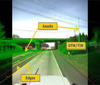
GIS is so much more than just inventorying assets and making maps. It also takes the data that aerial mapping, surveying, environmental, municipal, transportation, and other professionals develop to the next level. GIS experts will not only map the data but also analyze it to present different scenarios and find ways to make clients’ programs more efficient.
 Take a city’s pavement maintenance program, for example. Officials know how old their roads are, when they were last paved, and what their estimated life expectancies are. However, GIS can manage that information so they can approach their City Council and say with confidence that investing X number of dollars per year will keep their roads at their desired quality level (and save money in the process by using resources wisely).
GIS makes higher-end analysis and management like that possible, and that’s just one example.
So let us all raise the survey instrument or basemap of our choice and give three cheers to GIS Day – and celebrate the technology that’s so critical to our everyday practices.


Post a comment: