Assessing the Impacts of a High-Alpine Wildfire
 By Colin Barry, PG, CFM
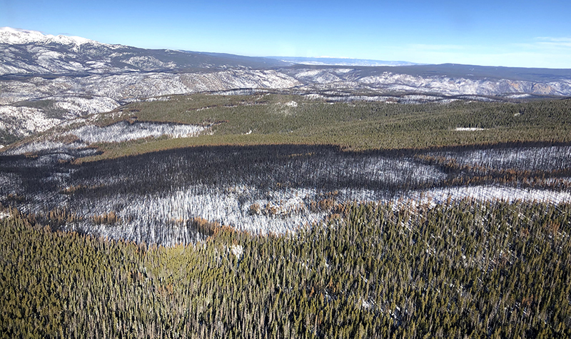
This year, Colorado experienced its largest wildfire in state history. The Cameron Peak fire started August 13 west of Fort Collins in the Arapaho and Roosevelt national forests, destroying nearly 209,000 heavily wooded acres before being contained on December 2.
With the devastating blaze still smoldering, emergency crews rushed to respond – in various capacities – and initiate first steps of repair work. That included assessing the severity of the burn and protecting water resources vital to cities across the arid Front Range of Colorado.

About the Expert:
Colin Barry, PG, CFM, a geomorphologist with more than five years of experience using geomorphic analyses that integrate hydrology, hydraulics, sediment transport, geology, and geomorphology to develop process-based understandings of fluvial system dynamics for a wide range of projects and clients, joined Ayres three days before the Cameron Peak fire broke out. Before coming to Ayres, he helped municipalities in southern Colorado model and prepare for increased flooding and sediment loads resulting from the Spring Creek Fire of 2018.
Studying the impacts to the forests is a critical part of that process and one that my colleagues and I have had the unique privilege to be part of. In early August, before much was known about the fire’s dynamics, a longtime client contacted us about developing “worst-case scenario” hydrologic modeling of the affected reservoir basins. How are they at risk – and in what ways? What are the water quality impacts? Are these reservoirs at risk of filling with newly mobilized sediment? How will burnt debris impact the structures? What is the expected increase in runoff? Our charge was to identify which reservoirs were at highest risk and identify areas for specific emergency mitigation.
Unique About the Cameron Peak Fire?
This fire started near the Continental Divide in a persistent snow zone where it’s not uncommon to have consistent snowpack from October to May. Fires don’t normally break out in persistent high alpine areas like this. Normally, they’re in intermittent zones (like areas slightly east where the state’s sixth largest wildfire, the High Park Fire of 2012, took place).
What Happens Within the Soil During a High-Severity Burn?
In addition to large burning and loss of vegetation and ground cover during wildfire events, a secondary and less obvious effect also takes place – heating and baking of the soil. That baking of the subsurface can form a temporary water repellant layer – which behaves almost like concrete, an impervious surface – and detrimentally impacts our watersheds.
How Do You Mitigate a Fire? And How do Hydrologic Models Assist in Mitigation?
To help as much as we could as quickly as we could, limited, short-term mitigation became priority No. 1. What could we do before the area became blanketed in snow and, in turn, unconsolidated sediment begins to mobilize with snow melt? Our goal was emergency mitigation before the snow fell to capture and store some of the sediment and improve the situation prior to long-term spring and summer mitigation work.
The process involved:
-
- Using preliminary fire data from the U.S. Forest Service to identify water resource infrastructure at risk. These included Chambers Lake, Barnes Meadow, Peterson Lake, Comanche, and Hourglass.
- Running a pre- and post-burn hydrologic models in HEC-HMS and adjusting parameters to simulate the burn (loss of vegetation, low infiltration, more erodible soils, faster watershed response to precipitation, etc.), our team started to asses which inflow areas were likely to supply the most sediment, debris, and ash into the reservoirs. This information was critical to prioritize our resources within our limited window prior to heavy snowfall.
- Going into the field to verify our initial priorities developed from modeling. We did this both on foot, hiking through high-severity burn areas, and in the air by helicopter.
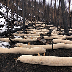
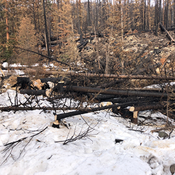
- Planning the logistics of what we were going to install at these areas. We recommended U.S. Forest Service-approved fiber logs – essentially, biodegradable and weed-free wattles that help slow flow velocities and store sediment upslope. We also looked at naturally occurring depositional regions within the streams to enhance by adding burnt logs to the channel. Over time, the stream will push and interlock them, creating a large logjam system with pockets and pools to store sediment.
- Exploring mulching for burn areas directly upslope from each reservoir to try to stabilize the soil and help vegetation recover faster. At $2,500 an acre, mulching can get expensive quickly so this will likely only be done in areas where other in-stream mitigation isn’t reasonable – and likely not until spring.
Until then, the team is continuing to monitor the burn area while preparing to mobilize and install more mitigation in the event of a weather break or early melt. With emergency measures now in place – and a better handle on how these systems are responding, those who manage and maintain the impacted reservoirs will be much better informed to move forward with long-term recovery in 2021.


Post a comment: