An Update – And Some Advice – On the (Delayed) New Datums That Are Coming
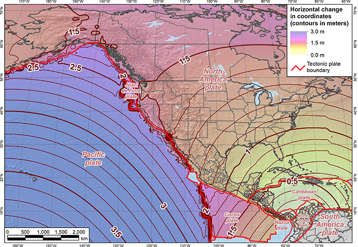
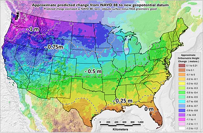
Now that we’ve crossed over into the year 2022, many members of the geospatial may feel like they’ve just dodged a collective bullet while the rest of us might be thinking, “What bullet is that?” I’m talking about the proverbial “carpet” under your feet shifting a couple of feet both horizontally and vertically in some areas of the country as part of the National Geodetic Survey’s (NGS) proposed move to new datums. Now that you have lived another day, geospatially speaking, how will you respond to this newfound opportunity?
What’s Scheduled to Happen with the National Spatial Reference System?
If you haven’t heard, changes are coming to improve the National Spatial Reference System – the system that defines latitude, longitude, height, and orientation – but the rollout of what were to be the new 2022 datums has been delayed several years. Here’s some background on the delay.
After getting deeper into developing these new datums, along with experiencing the effects of staffing shortages and COVID, NGS has gained a much better understanding of not only the technical details of the new datums but also the significant effort to implement the datums and to manage all the cascading changes to their own internal programs, systems, and software. At this time, NGS is saying that the actual implementation of the new datums will occur sometime after the year 2025.
What Does the Delayed Release of Modernized NSRS Mean for Me?
I choose to look at this delay as a gift of time that will allow us to better prepare for the transition. My mantra from the start has been “Don’t be scared. Be prepared.” It should be instructional to us that if NGS is stepping back and delaying the implementation – in part because of its complexity – we should expect our own transition to the new datums to also be complex. The complexity of implementing the new datums is not only technical but also involves institutional workflow revisions and interagency cooperation and timing.
My recommendation to organizations that deal with any type of geospatial data is to start planning now if you haven’t already done so. The Wisconsin Spatial Reference System 2022 Task Force (WSRS2022), which I am actively involved with, has been chipping away at this issue for over three years. The mission of the WSRS2022 Task Force is to help ensure the successful implementation of the new reference systems across the state.
The Task Force is a resource, but the actual work of doing the data conversions and developing workflows specific to organizations will fall on our geospatial community.
How Do We Prepare for the New Datums If All the Details Haven’t Been Worked Out Yet?
There are foundational elements that members of the geospatial community can work on now – even as a part of their normal organizational duties – that will ensure we’re all in a better position when the change happens. Here are a few suggestions on how to be better prepared:
- Inventory your data, including both internal data and external data you depend on.
- If a dataset does not have metadata associated with it, develop it now.
- Assign a priority or rate how critical each dataset is to your operation.
- Decide if each dataset will need to be converted. Some data is not worth the effort, and some can tolerate approximate “on the fly” transformations and still function as needed.
- Identify all the software you use that either does reprojections or transformations or even views geospatial data and be prepared to assess if the software vendor is prepared to update the software if it is critical to your organization.
- Share that list of software with the WSRS2022 Task Force so we can pass it on to the NGS, who is communicating with software vendors regarding their preparedness.
- Do you maintain your own control network? Examine what would be needed to link your network to the “best” NSRS passive or CORS stations.
- Consider obtaining GPS observations on critical survey marks that control your long-term infrastructure or systemwide projects and submitting OPUS shared solutions to the NGS GPS on Benchmarks program. The deadline for submission to this program has been extended until December 21, 2022.
- To identify survey mark candidates for GPS on Benchmarks observations, think “what marks will require accurate (small error estimates) horizontal or vertical coordinates or elevations in the new 2022 datums to support my project or system needs?” With the time dependent nature of the new datums, any mark with observations older than 10 years may be found in the NGS database but will have higher error estimates associated with them which may not support your needs.
- Consider implementing a program to systematically obtain GPS observations on critical marks every 10 years.
- Include contract language and budget for a robust set of physical survey control marks in all your future projects to ensure that projects can be brought forward to the new datums when needed.
- Consider requiring project control surveys include GPS on Benchmarks observations and submittal to NGS.
- Last but not least, start a dialog with organizations and agencies that are the custodians of any external data your organization depends on.


Post a comment: