Award Winning Project Adds Resilience to Canyon Highway
 By John Hunt, PE
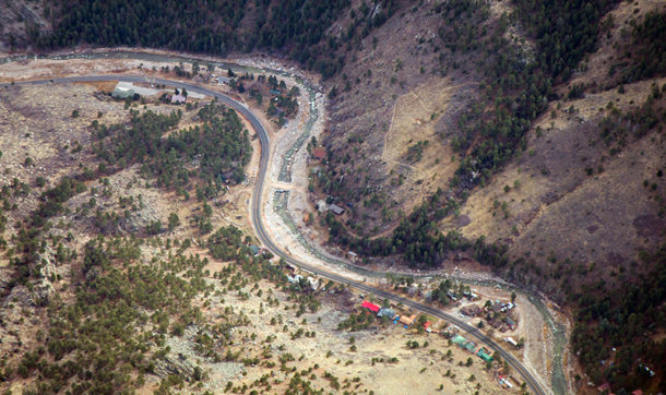
In September 2013 a flood devastated parts of Colorado, taking lives, destroying homes, and damaging critical infrastructure and transportation networks. The flooding was especially crippling to many mountain corridors north of Denver, where hundreds of miles of road were washed out, cutting off access to many small mountain towns. Among the worst damage was to the Big Thompson River canyon, where over 10 miles of US 34 roadway embankment were destroyed, homes were washed out, and two lives were lost.
US 34 is a critical route for tourism, as it stretches from Loveland, Colorado, to the tourist destination town of Estes Park at the base of Rocky Mountain National Park. The flood cut off this main route to Estes Park, increasing pressure to fix the highway as quickly as possible to allow tourists back into the town and restore safe access to the many residents along the corridor.
Under the direction of the Colorado Department of Transportation (CDOT), temporary emergency repairs were completed in a matter of weeks. Then CDOT shifted its attention to assembling a team to design and construct permanent repairs for the highway.
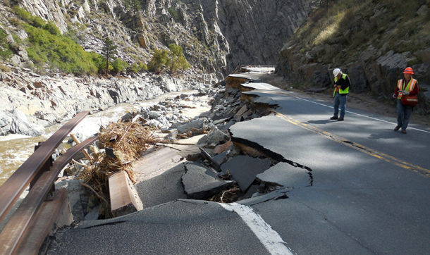
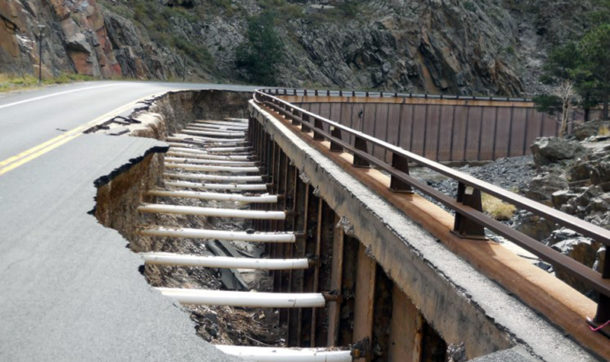 Designing a roadway in a steep canyon environment such as US 34 poses challenges, requiring specific hydraulic engineering expertise. A major driving factor leading to the flood damage in this corridor was high velocities and depths of flood flows caused by the steep, confined, and constricted Big Thompson river. With extremely high velocities and hydraulic shear stresses, the destructive forces were severe.
Two-dimensional hydraulic modeling recreated the conditions of the 2013 flood. Sections of the highway where the model predicted a high erosion potential proved to be consistent with the reality of what happened in the flood. The next step was to model simulations of future flood conditions for the proposed highway configuration. Modeling results were used to determine the correct size of rock riprap for protecting the highway embankment, to figure out how deeply the embankment protections needed to be embedded into the ground, to assess the impacts of access bridge design, and to determine any potential negative impact the design would have on the opposite bank.
Armoring and other treatments were designed to protect the highway embankment from suffering the same level of massive destruction in a future 100-year flood. The embankment protection came in the form of conventional loose rock riprap and, in some situations, an innovative technique called matrix riprap. The SRH-2D program within the SMS modeling system was used in combination with ArcGIS tools to create an automated procedure to rapidly perform scour calculations and riprap stone sizing.
Two-dimensional modeling produces more reliable and useful results than 1D modeling, providing an accurate understanding of velocity, depth, and shear stress. Ultimately, hydraulic engineering methods used in the US 34 project, such as 2D modeling, can be used as a model for future highway design projects within canyon environments in similar settings.
Beyond embankment protection, engineers conducted a hydraulic analysis of the access bridges along the corridor, including analyzing waterway capacity of the bridges as well as the vertical clearance between the flood level and the bottom of the bridge structure.
Ayres Associates was part of the US 34 design team led by Jacobs Engineering. Ayres provided the scour embankment protection designs for six access bridges, embankment protection design for 15 miles in the river canyon, and conceptual countermeasure designs for several high-damage areas.
 Design of the $280 million project started in fall 2015, and construction was finished in May 2018, under budget and two years ahead of schedule. The project was just named “Project of the Year, Best Highway Bridge” by ENR (Engineering News-Record) magazine.
The project served as a high-profile example of the critical link between river hydraulics and road design. As Doug Stremel, the design project manager for Jacobs, explained to ENR, the team had to evaluate the river and the roadway as one system: “They must coexist. It’s a river with a road problem as much as the other way around.”


Post a comment: