Projects That Are Designed With a Sense of Place Never Miss the Mark
 Have you ever seen a building or any other structure that seemed out of place – almost as if it had been dropped in from outer space? A well-planned project – whether it is designed for a private company or a public entity – generally does not have that otherworldly feeling. Instead, it seems to fit right in and even accentuate the area that surrounds it. It might even allude subtly to the history of the space it occupies.
Enjoying the ribbon cutting for a project that fits seamlessly into its setting is not an occasion one arrives at by accident. A proper inventory and analysis on the front end of a project allows a client to understand the physical constraints of a site while also taking advantage of the opportunities the site offers.
A proper physical inventory of a potential site for a building, park, or other facility takes a look at what buildings are there and what the topography is like. The analysis then looks at things like transportation corridors, utility locations, slope constraints, brownfields, and the history of the site.
The analysis that follows allows the client to plan for these items as well as water, sanitary, and electric needs while avoiding utility conflicts and taking full advantage of opportunities to create unique places that evoke the vibe of the community and hearken back to its past.
The next step is programming the space by listing a wish list of features, dividing the space into sectors, and then placing all the feasible pieces into the appropriate sectors. After soliciting the client’s opinion on the programming (and the public’s opinion if it is a public space), the project moves to the preliminary plan phase, in which two or three alternative plans are drawn up. When the preferred plan is developed, Ayres landscape architects use SketchUp and LumenRT software programs to convert the plans to an interactive 3-D image that allows Ayres landscape architects and designers to tweak the design live while the client is reviewing the site design.
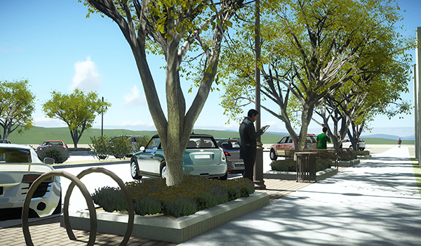
From there, the process involves choosing an alternative and settling on the finishing touches that will subtly convey the feel the client is going for. In the case of the ongoing Altoona River Prairie Development project in Altoona, Wisconsin, Ayres suggested that the City of Altoona infuse its new commercial and park development with river, prairie, and railroad themes that reflect the surrounding landscape and the City’s railroading heritage.
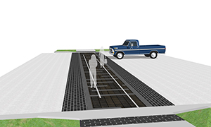 Through color, texture, and shape, the themes manifest themselves in many ways in the development’s design:
- A mixture of grasses and flowers for a prairie look in the public plantings
- Crosswalk markings that evoke weathered railroad track and ties, as shown in the accompanying photo
- A public pavilion reflecting prairie school architecture
- A railroad and prairie hybrid styling for the area’s lamp posts
A very straightforward and practical nod to a sense of place stands outside the new JAMF Software office in downtown Eau Claire, Wisconsin. JAMF staff knew how many people flock each summer to Phoenix Park across the street from their office, bringing inner tubes and other flotation devices to launch at the confluence of the Eau Claire and Chippewa Rivers for a float down the Chippewa. Often those “tubers” are in search of an air compressor to fill their river vehicles, and JAMF decided to post one along the sidewalk just outside its office. When people are downtown, it’s all about the river, especially in the summertime.
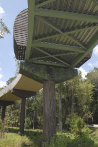 Even a bridge can be designed to fit intentionally into its surroundings, as exemplified by the General Hutchison Pedestrian Bridge that carries the Cross Seminole County Trail over U.S. 17-92 at General Hutchison Road in Seminole County, Florida. Ayres Associates designed the bridge in an “S” shape to mimic the winding nature of the trail, and parts of the bridge were painted green to reflect the wooded areas nearby. The bridge piers were even painted to resemble trees because the bridge provides a link to Big Tree Park.
In Cheyenne, Wyoming, and Yuma, Arizona, two Ayres-assisted brownfield redevelopment projects are all about creating connectivity that will help residents and visitors rediscover some great places, says Scott Wilson, vice president of environmental services.
Cheyenne’s West Edge project aims to reduce flooding and improve stormwater handling in an area near downtown while creating a greenspace where people can take a walk and meet their neighbors or perhaps gather to hear some music or buy local produce. This will be quite an improvement from the unsightly old parking lots and lack of sidewalks that now characterize this area, Scott points out. Housing developers and businesses are expected to find the site lucrative, especially with linear parks and walking and biking trails serving as connections to assets like the popular refurbished railroad depot downtown.
In Yuma the Colorado River and the Yuma Territorial Prison Museum are obvious attractions to which Ayres Associates is suggesting the City provide trail connections, along with an overlooked overlook, Black Hill, which provides commanding views of the area. The goal is to turn an unattractive downtown railroad property into a well-connected entertainment district with new streets and trails that connect to and enhance the Main Street business district and the surrounding attractions.
Is there a project in your neck of the woods that has a strong sense of place? Please tell us about it below! And if you’re dreaming up a project that needs a sense of place, we invite you to contact Scott, or the landscape architecture and planning staff in our Madison, WI, office.
Post a comment: